 |
eClassroom Journal for Maine |
 |
|
eClassroom Journal for Maine |
|
| Click on any outlined image to see a larger version of the image.
Anywhere you see a | |
| Previous State (New Hampshire) | Next State (Massachusetts) |
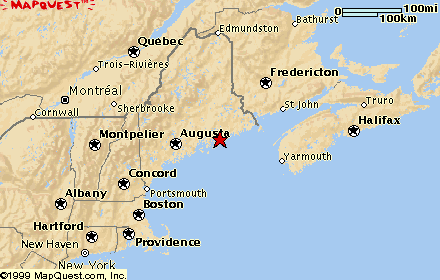
| September 12, 2000 Lubec, Maine
|
Lubec, Maine, and Quoddy Point Lighthouse
Please see the September 12, 2000 entry in Flat Teddy's Journal. |
| September 12, 2000 Campobello Island, New Brunswick, Canada
|
Campobello Island
Please see the September 12, 2000 entry in Flat Teddy's Journal. |
| September 13, 2000
Bar Harbor, Maine
|
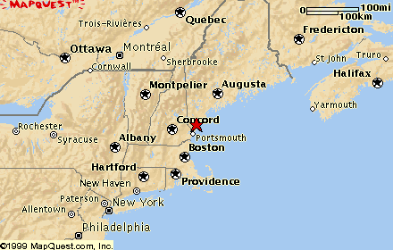
 Acadia National Park
Welcome to Acadia National Park! You are looking north from the top of Cadillac Mountain down over the lovely little town of Bar Harbor and beautiful blue Frenchman Bay. Cadillac Mountain is the highest point on Mount Desert Island, and the land in the distance, across Frenchman Bay, is the mainland of Maine. (The Maine-land, you might say.) Cadillac Mountain, at 1530 feet elevation, is actually the highest point of land on the whole eastern United States coastline. The name Acadia was given to the region by the early French explorers, and it was one of them, Samuel Champlain, who named the island Mount Desert for the bare rocky top of Cadillac Mountain. The region was scored north to south by glaciers, and all the lakes on Mount Desert Island run in a north-south direction in the valleys carved by the glaciers. Somes Sound, on the southern part of the island and extending north into the middle of it, is actually a fjord--the only one on the east coast of the United States. A fjord is a glacial river valley drowned by the sea. It's estimated that the ice sheet that covered this region was two miles thick in places. I enjoyed a four-mile bike ride on one of the carriage paths that John D. Rockefeller had built here on the island. Between 1915 and 1933 he financed and directed the building of 57 miles of carriage roads--woodland routes free of motor vehicles--for hikers, bicyclists, horseback riders, and carriages. I am thankful for his foresight to help preserve this area from private development so that it was available for national park designation when the time came. He donated to the park more than 11,000 acres, about one-third of the total area. Here is a question for you to find the answer for: what is the historical and cultural connection between the names Acadia and Cajun? [Hint: there is one!] Here are some links to help you find the answer: |
| September 21, 2000
Brunswick, Maine
|
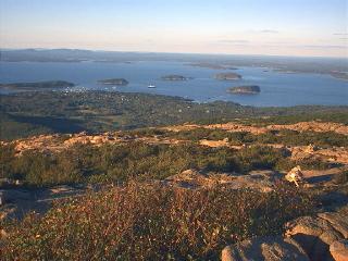
 First Parish Church, Congregational
First Parish Church, Congregational, on Maine Street in Brunswick, Maine, is reportedly where Harriet Beecher Stowe heard the sermon that inspired her to write Uncle Tom's Cabin. This church has been in continuous service since 1717. Maine Street was originally known as Twelve Rod Road because it was laid out to be twelve rods wide. That computes to 198 feet across. The group of proprieters who originally laid out the town planned it to have a grid of wide streets. As I drove into the town, I felt I'd left New England with its narrow, winding roads and streets and I was back home in good old Fort Collins! But it was only a dream. |
| September 21, 2000
Brunswick, Maine
|
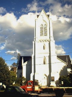
 Bowdoin College
This sign stands on the corner opposite First Parish Church in Brunswick, Maine, and invites one to enter the grounds of Bowdoin College. In my mind, I was pronouncing the name phonetically, but later when I said the name aloud to a very proper New England woman, I was promptly corrected in my pronunciation. "It's Boh'-din, dahling," she said, looking down her nose at me. So I give it to you, so that when you toss out the name correctly pronounced, you will show yourself to be a cultured traveler. Famous students of this college were Nathaniel Hawthorne, Henry Wadsworth Longfellow, President Franklin Pierce, and Arctic explorers Robert Peary and Donald MacMillan. Inspired by a college friendship (or at least acquaintanceship), Nathaniel Hawthorne wrote a biography of Franklin Pierce. Many of Hawthorne's otherwise-faithful readers refused to read it because Pierce had been such a weak, ineffective president. |
| September 21, 2000
Yarmouth, Maine
|
 Eartha at the
DeLorme Map Store
Eartha at the
DeLorme Map Store
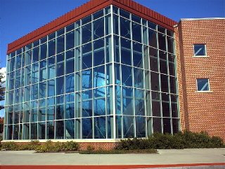
Inside the building in the picture you can see a huge globe of the Earth, named Eartha, which rotates and revolves constantly, just like the Earth. Eartha is over 41 feet in diameter. It's the largest printed image of the Earth ever made, so say the creators at the DeLorme Map Company, in Yarmouth, Maine. The information used to create the map is from a database built from satellite imagery, shaded relief, colored bathymetry (ocean-depth data), and information about road networks and urban areas. The database contains the equivalent of 214 CD-ROMs of information. One inch on Eartha equals nearly 16 miles on Earth. Eartha rotates on its axis at 23.5 degrees, just as the Earth does. It takes 18 minutes for Eartha to do a complete rotation and revolution. I walked up three flights of stairs inside the building to view Eartha at different angles, lastly looking at it from the level of the Arctic circle. My favorite view was from down on the floor, looking straight across at Australia and New Zealand. You'd have to go down into the basement to look up at Antarctica, and that stairway was closed off. I could look down through the opening in the floor into that area, however, where the wheels and gears are that drive Eartha. I DO love maps and globes, and this one has to be my favorite of all! |
| September 21, 2000
Portland, Maine
|
 Wadsworth-Longfellow House
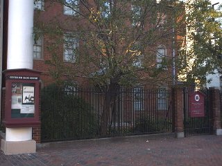
This large house, now surrounded by tall buildings on a busy downtown street in Portland, Maine, was built in 1785 and 1786 by General Peleg Wadsworth. He was Henry Wadsworth Longfellow's grandfather (the father of Henry's mother). When Henry was a boy he lived in this house. The house was built of bricks that were shipped up from Philadelphia on a barge. It was the first brick home in Portland. Originally, it was a two-story house; the third story was added in 1815. |
| September 22, 2000
Wells, Maine
|
 Rachel Carson National Wildlife Refuge
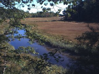
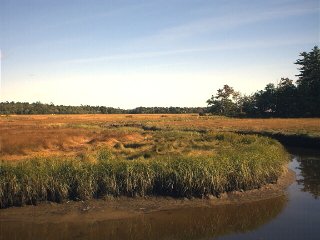
These two pictures are of the Rachel Carson National Wildlife Refuge area, a salt marsh on the southern Maine coast. Rachel Carson was a world-renowned marine biologist, author, and environmentalist. She worked for the U.S. Fish and Wildlife Service for many years, during which time she wrote Silent Spring in 1962. The book explains the ecological connections between humans and all creatures of the Earth, a concept which was radical for its time. Ms. Carson links the unrestrained use of chemical pesticides with dire biological consequences. Both industry and government pressured her to abandon her research for the book, but she persevered. Her work brought to the national consciousness the need for environmental education and an appreciation of the study of ecology. She died of cancer in 1964, and to honor her, the Coastal Maine National Wildlife Refuge was renamed in her memory in 1969. In the first picture you can see the small tidal creek, Branch Brook, meandering through the marsh at low tide. The continual exchange of fresh and salt water in the marsh helps support a complex marine food web. In the second picture you see the two principal types of grasses that grow in the marsh: saltwater cordgrass (tall grass with stiff, pointed leaves that grows along the creek) and salt hay (which grows above mean high tide and forms the meadows of grass of the high marsh). |
| Previous State (New Hampshire) | Next state (Massachusetts) |
|
Links Back to the main page... |