 |
eClassroom Flat Teddy's Journal, Page 1 |
 |
|
eClassroom Flat Teddy's Journal, Page 1 |
|
| Click on any outlined image to see
a larger version of the image.
Anywhere you see a | |
| Next page (2) | |
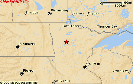
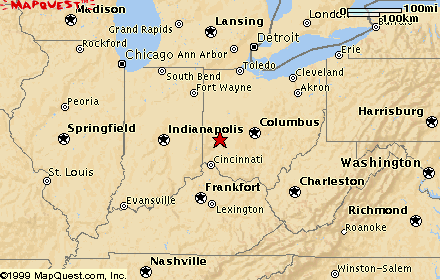
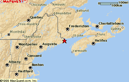
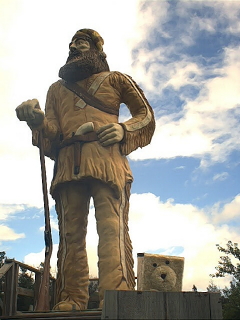
| August 5, 2000 Lake Itasca, Minnesota
|
 Headwaters of the Mississippi River
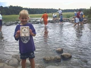
This is a picture of Flat Teddy, who is traveling with Mrs. Pearson and
helping you learn some facts about the places he visits. He's being
held by a little girl he just met named Anna, who will be in first grade
next year here in Minnesota Native Americans
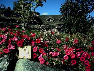
The average surface speed of the Mississippi River is 1.2 miles per hour, about one third as fast as people walk. So, a raindrop falling in Lake Itasca would arrive at the mouth of the Mississippi, on the Gulf of Mexico, in about 90 days. In world ranking, the Mississippi River system has the fourth largest drainage basin and is the third longest in river miles. Although temperatures may reach forty degrees below zero in the winter, the area at the rocks where the river flows out of the lake rarely freezes over. Springs feed enough water into the lake to continue the river's flow year round. |
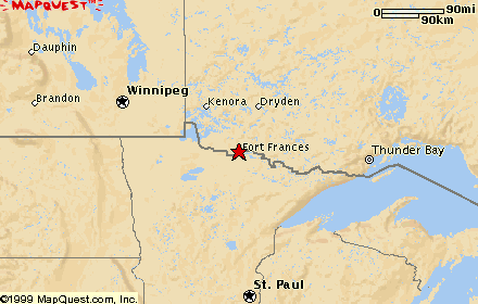
| August 9, 2000 Voyageurs National Park, near International Falls, Minnesota
|
 Flat Teddy learns about the Voyageurs
As the
fur trade the Canadian Voyageurs possess lively and fickle dispositions, and they are rarely subject to depression of spirits of long continuance, even when in circumstances the most adverse. Although what they consider good eating and drinking constitutes their chief good, yet when necessity compels them to it, they submit to great privation and hardship, not only without complaining, but even with cheerfulness and gaiety.Harmon continued: ...Trifling provocations will often throw them into a rage, but they are easily appeased when in anger, and they never harbour a revengeful purpose against those by whom they conceive that they have been injured.The voyageurs came to know the country well, and they, along with the Indians and lumberjacks, gave this region the bulk of its place names, such as Grassy Portage, Kabetogama Lake, and Cutover Island. Note that the place names are predominantly water-related. Even today, the ridges and hilltops in the park bear no names. (See Mrs. Pearson's journal report on
Voyageurs National Park |
| August 21, 2000 Mackinac Island, Michigan
|
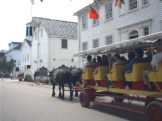
 Mackinac (pronounced Mack'-in-ah) Island
Flat Teddy stepped back in history to visit Mackinac Island, in
Lake Huron
|
| August 25, 2000 Wapakoneta, Ohio
|
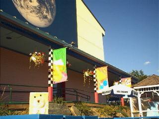
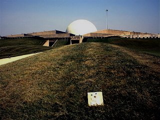 Neil Armstrong Space Museum
This building is the
Neil Armstrong Space Museum, which looks like a big full moon rising
right out of the museum. It is in the town of
Wapakoneta, Ohio, which is the
birthplace of Neil
Armstrong, first man
to walk
on the moon, on July 20, 1969. In the museum you can see the
Gemini 8
space capsule, in which Armstrong completed the first spacecraft docking
in orbit. Under that moon-shaped dome is the "astrotheater," where you can
experience what it was like to go to the moon.
It's interesting that several businesses and streets in Wapakoneta are named
Astro or Apollo or other terms from space exploration or from
the trips to the moon And this from Flat Teddy: "Hey, you guys, this place was really COOL! I wish I could have met Neil Armstrong." |
| August 27, 2000 Dayton, Ohio
|
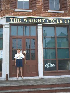 Flat Teddy Visits the Wright Brothers
 Mrs. Pearson and I are standing in front of the building where the Wright brothers had their second bicycle shop in Dayton, Ohio, from 1895-1897. It was while Orville and Wilbur were working in this building that they really began to get interested in flying. They moved to their third shop, just around the corner and down the street a half block from this shop, because it had a big room at the back where they could build a wooden airplane big enough for people to fit in. That was the shop we saw last week up in Dearborn, Michigan, at Henry Ford's Village. After we took this picture in Dayton, Mrs. Pearson took me around the corner and down the street, and there we saw the empty space between two old two-story brick buildings where the third shop used to be. It's still a vacant lot, after Mr. Ford moved that old shop out of there and to Dearborn many years ago. |
| August 30, 2000 Niagara, New York
|
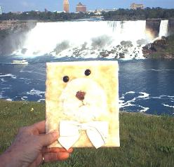
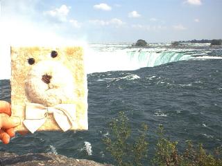
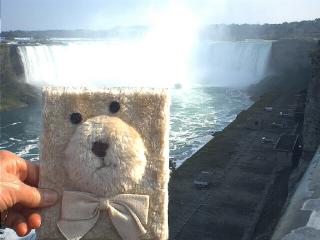 Niagara Falls
The first picture you see is of the American Falls. The second picture is from above the top of the Canadian Falls, and the third picture is from below the Canadian Falls. The Niagara River flows north out of Lake Erie and drops over a gigantic stone ledge down to the level of Lake Ontario. The ledge creates Niagara Falls. (Actually, in technical and proper geological terms, the level of the earth at the top of the falls is called the Niagara Escarpment, and it is higher because of that land rising up when the great ice sheet sitting on top of it melted, leaving Lake Erie in its place.) The U.S.-Canadian border runs through the middle of Lake Erie, down the middle of the Niagara River, and through the middle of Lake Ontario. Right at the top of Niagara Falls, there is a big island in the river called Goat Island, which is in the United States' half of the river. From its banks to the Ontario side of the river the falls are called the Canadian Falls, even though part of that water is technically in the U.S. The falls that drop off the part of the ledge closest to the New York State side of the river are called the American Falls. The Canadian Falls, sometimes called Horseshoe Falls, drop 176 feet along a curving crest that stretches 2,200 feet. The American Falls drop further, 184 feet, but their crest is only 1,075 feet wide and is relatively straight. There is one other waterfall there, named Bridal Veil, which is near the American Falls and is formed by water flowing over the ledge between Goat Island and Luna Island. About 1.5 million gallons of water per second flow over the falls during the daytime. At night after the tourists leave, about half the water in the river above the falls is diverted through tunnels to hydroelectric generating plants. Diverting the water overnight is accomplishing two purposes: creation of electricity, and also slowing down the erosion of the falls. Before diversion, the falls were eroding at about two inches a year. Now, the figure is down to around one inch of erosion a year. Ships traveling the Great Lakes Waterway have to bypass this river to travel from Lake Ontario up to Lake Erie. There is a canal about twenty miles long that carries ships between the lakes called the Welland Canal: it passes through a peninsula in Ontario between the lakes. Flat Teddy adds: I almost got wet in all the spray that flies up from the Canadian falls. Mrs. Pearson had to take my picture above the falls where there wasn't any spray yet and then way downstream of them so that I didn't get ruined. Of course, she got wet, but she dries off. What a loud noise all that water makes! |
| September 8, 2000 Shelburne, Vermont
|
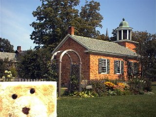
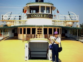
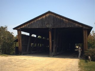 Shelburne Museum
These three pictures were taken in the Shelburne Museum in Shelburne, Vermont. The museum is like Deerfield Village in Michigan and like the Adirondack Museum in New York state, in that it is a collection of buildings brought from different parts of the country to one big outdoor location. These buildings at the Shelburne were brought from all over New England to preserve a history of early New England life. The first picture shows Flat Teddy near a one-room country schoolhouse. This schoolhouse is a little fancier than the white wooden one that Grandma Moses attended when she was a girl, but inside it's just the same--one big classroom for all the students who went there. There could have been anywhere from a few students to twenty or thirty, in grades kindergarten through eight. There were two cloakrooms by the entry door, one for the girls and one for the boys. There was a big stove that had to be stoked with wood or coal all day long to provide heat for the students and the teacher. Often the oldest boy in the school got that job. The second picture is of the Ticonderoga, a side-wheel paddle steamer built in 1906 that carried people and cargo up and down Lake Champlain all of its career. One of the museum employees on board the boat took Flat Teddy's and Mrs. Pearson's picture. The third picture is of a two-lane covered bridge that was built in 1845 in Cambridge, Vermont. The roof on a covered bridge kept the snow and sleet off the bridge so that it didn't get icy. That kept horses and wagons from slipping when they crossed the bridge in winter. Most covered bridges in this region of New England are only one lane wide. This one is unusual. Notice it also has a covered footpath on the left side so that walkers across the bridge would be safe, too. |
| September 9, 2000 Fairfield, Vermont
|
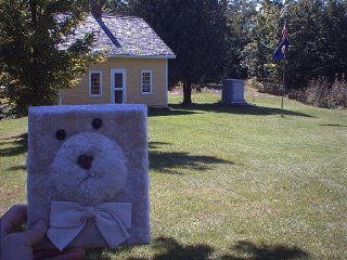 Chester Arthur Birthplace
Flat Teddy is visiting this little house off by itself in the woods of northern Vermont. It was most likely the birthplace of Chester Arthur, who would grow up to be President of the United States. Historians aren't completely sure if Arthur was born in 1829 or 1830. When he was running for Vice President along with Garfield, who was running for President, some people tried to prove that Arthur was actually born in Canada when his mother was visiting her family across the border. If he had been born in Canada he wouldn't have been eligible to run for President or Vice-President of the United States. At the time, he must have had some proof of his U.S. birth. Garfield had been president for only four months when he was shot by an assassin. He lived 79 days after he was shot but eventually died. Arthur served out the rest of the term. Although Arthur had been born into the family of a Baptist minister, he became dishonest in his political life in the years before he became President. Many of his fellow political cronies thought they'd have an easy time getting away with their illegal schemes once he was in office, but it didn't work that way. President Arthur developed into a more honest person once he assumed the office, and he did a much better job of it than anyone would have predicted. Teddy and I had to drive four miles on a gravel road through tree tunnels and up steep hills to get to this cabin, high in the woods in northern Vermont. It was a beautiful location, but oh how we had to work to get there! We were the only visitors who had signed the guest book for that day when we were there at 2:30 in the afternoon. The lady working there had worked in her daughter's school last year and had heard of Flat Stanley, so she was very glad to meet Flat Teddy. |
| September 9, 2000 Stowe, Vermont
|
 Trapp Family Lodge
Here Flat Teddy is visiting the Trapp Family Lodge high on a meadow- and forest-draped mountain above the town of Stowe, Vermont. This huge complex, of which you're seeing a small part of just one building, was built by the von Trapp family after they escaped from the Nazis in Austria during World War II. They are the family that the movie "The Sound of Music" was about. They came here, built a lodge for tourists, and also toured the country, singing. We didn't see any members of the Trapp family, but we certainly enjoyed walking around the beautiful buildings and seeing all the lawns and flower gardens and window boxes full of blooming plants. There were many guests of the lodge arriving, and a wedding was going on down in one of the lower meadows. It was a very busy place. I kept imagining I was hearing singing coming from far away--"The hills are alive with the sound of music," and "Climb every mountain; ford every stream." Alas, it wasn't any of the von Trapp family--just my imagination. |
| September 9, 2000 Waterbury, Vermont
|
 Ben & Jerry's Ice Cream Factory
Flat Teddy had a long-awaited treat when we finally arrived at Ben and Jerry's ice cream factory outside Waterbury, Vermont--he got to see the famous ice cream being made. Mrs. Pearson had to eat Teddy's free ice cream sample for him, of course, so he didn't get all messy. It was a hard job for Mrs. Pearson to do, but somebody had to do it. Ben and Jerry's factory is in a wide, green, grass-carpeted valley in Vermont where there are many cows around the countryside nearby to furnish the rich milk for the ice cream. Everyone who works at the factory seems to be having fun, and they share that excitement with all the visitors. They also tell lots of jokes. It's a very happy place to be. |
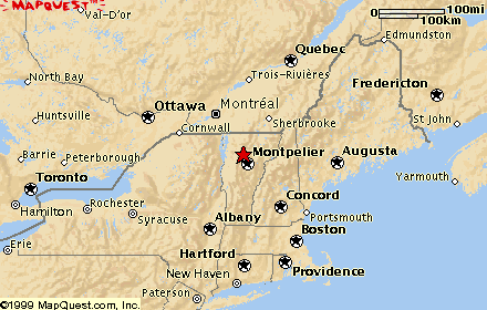
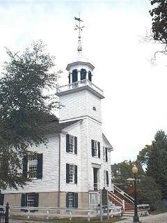
| September 10, 2000 Montpelier, Vermont
|
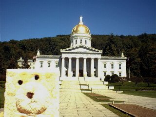 Vermont State Capitol
The Vermont state capitol building in
Montpelier had a flat little
visitor on Sunday afternoon, September 10. Flat Teddy had a look around. He
learned that the building was made of granite taken from a
quarry in a
nearby town of Barre. The figure on
the gold dome is Ceres,
Roman
goddess of agriculture. Inside there is a statue of a famous Vermonter,
Revolutionary War
|
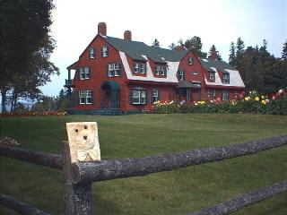
| September 10, 2000 Franconia, New Hampshire
|
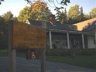 Robert Frost Farm
Flat Teddy and I visited the farm which Robert Frost purchased and where he lived with his young family for five years, outside the little town of Franconia, New Hampshire. The sign in front of the farmhouse says, "The Frost Place: A Center for Poetry and the Arts." It's called that because every summer a promising poet is invited to come live in a part of the house that isn't open to tourists and write poetry. When Teddy and I were there we saw a woman sitting on the front porch looking out across the valley to the highest peaks in the White Mountain range, painting a picture. We didn't see the resident poet at work. Inside the house we could walk through two rooms where Frost did most of his writing when he lived there. Inside the small barn on the property we sat in folding chairs and watched a video about Robert Frost. It told about his life and showed him at President Kennedy's inauguration. Later we walked the Poetry Trail up the hill behind the house and through the forest. Every now and then we'd stop to read plaques that displayed Frost poems along the trail. Where there was a fork in the path, we read one of my favorite poems of his about "the road less taken." At another place along the trail, where the woods were quite thick, we read the poem that Frost said was his favorite of all his work: "Stopping By Woods on a Snowy Evening." It's also one of my favorites. Along that trail even the light looked green because of the thick canopy of green leaves overhead. Strangely, I would see a brilliant red maple leaf on the path or off in the forest every few feet. I kept looking up but saw no trees turning red. And then finally, near the crest of the trail before it looped back down to the farmhouse I saw the sugar maple that had provided all the rubies among the emeralds of the forest--a brilliant, glowing tree shimmering in the late-afternoon sunshine, dropping its leaves a few at a time as if blessing the forest. Teddy and I both said, "Ahhhh." |
| September 11, 2000 New Hampshire/Maine border
|
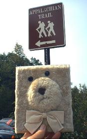 Appalachian Trail
Just outside of Bennington, Vermont, two weeks earlier, the highway I was on had crossed the Appalachian Trail. I hadn't been able to stop there because of heavy traffic on the highway not enabling me to slow down enough to turn into the parking lot. This morning in New Hampshire, near the Maine state line, I was prepared for the trail, having seen on the map before I started out where it crossed the highway. Traffic was light, and I turned into the parking lot, where I took this picture of Flat Teddy. Then Teddy and I decided to hike a bit of the trail. We stepped onto the trail at the edge of the woods, stopping a moment to read the signboard. There was a folded note fastened to the sign, for "Steve Jones, through hiker." (I changed the name to preserve the real person's identity.) The term through hiker meant that he was hiking the entire 2,100 miles of the trail in one season. Most through hikers start on the trail early in March at Springer Mountain in Georgia and hike north through the Appalachian Mountains for the next couple of months. They need to be at the end of the trail at Mt. Katahdin in Maine early in October, after which time it's likely to begin snowing up there. That's approximately seven months to hike 2100 miles, which computes to an average of 10 to 12 miles a day, taking into account rest days. There are also days when one comes off the trail into towns to purchase food or to pick up food that has been mailed or brought to the hiker. Or to shower and do laundry, to name two other necessities. The Appalachian Trail climbs more than 350 peaks that are over 5,000 feet high on its route from Georgia to Maine. The highest point on the trail is Clingman's Dome in Tennessee, at 6,700 feet. The Appalachian Trail was formally completed in 1937 and for a time was the longest hiking trail in the United States. It has since been surpassed in length by the Pacific Crest and the Continental Divide trails. As Teddy and I hiked we passed through dark and deep woods. The trail was a tangle of tree roots that we had to be very careful of. This was a sunny day, above the ceiling of leaves over our heads, but I can imagine what hiking over those slippery tree roots would be like on a rainy day, of which there are many. I have the greatest respect for anyone who attempts the entire trail or even sections of it. However, there is one mile of the Appalachian Trail that is now mine! Only 2099 to go! |
| September 12, 2000 Lubec, Maine
|
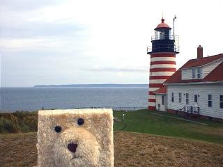 Lubec, Maine, and Quoddy Point Lighthouse
Lubec, Maine, is the easternmost town in the United States. You can see it across the water, in the first picture. Where I took this picture, Flat Teddy and I were actually in Canada looking over at Lubec across the Lubec Narrows. In the second picture you see nearby Quoddy Head Lighthouse, which sits a few miles southeast of Lubec and therefore is on the easternmost point of land. That makes it the spot in the United States which receives the first rays of the sun's light every morning. The island in the distance beyond the lighthouse belongs to Canada. The U.S.-Canadian border passes through the Lubec Narrows, which is crossed by the Franklin D. Roosevelt Memorial Bridge from Lubec to Campobello Island, a part of New Brunswick, Canada. You'll read more about that island in the next report. Maine is referred to as "Down East." This term began back in the days of sailing vessels which departed from Boston, catching the prevailing westerlies to sail downwind toward Maine, creating the phrase "going down to Maine" or "Down East." |
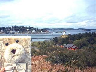
| September 12, 2000 Campobello Island, New Brunswick, Canada
|
 Campobello Island
Flat Teddy and I paid a visit to Franklin and Eleanor Roosevelt's summer home on Campobello Island, which is a part of New Brunswick, Canada. Franklin D. Roosevelt's father, James, first went to Campobello Island in 1883 with his wife and one-year-old son. Franklin spent every summer there as a child and began taking his wife and children there when he became an adult. This "cottage," as the Roosevelts called it, has 34 rooms. It was on this island in the summer of 1920 that Mr. Roosevelt was stricken with the polio virus. He was carried on a stretcher down to the dock below the house. There he was put on a boat that took him to Eastport, Maine. And in Eastport he was carried on board a train that took him to New York. Nine years later, after this illness had paralyzed his legs, he was elected governor of New York state. Later he became President of the United States, winning an unprecedented four terms! He died in office in his fourth term. |
| Next page (2) | |
|
Links Back to the main page... |