 |
eClassroom Journal for August, 2000 |
 |
|
eClassroom Journal for August, 2000 |
|
| Click on any outlined image to see a larger version of the image.
Anywhere you see a | |
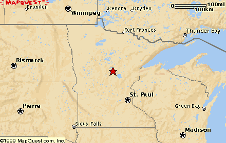
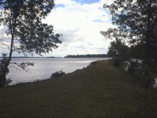
| July 30, 2000 Ogallala, Nebraska
|
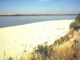 Oregon Trail
I camped beside Lake
McConaughy |
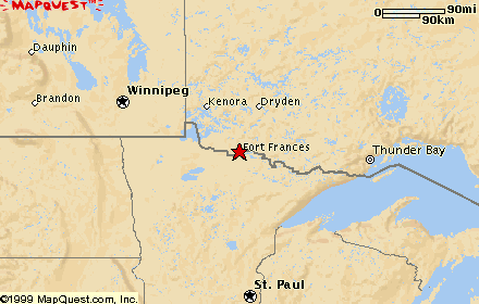
| August 6, 2000 Knox County, Nebraska
|
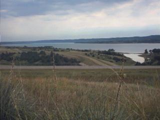 The Missouri River and Lewis and Clark's journey
President
Thomas Jefferson here the Man who left us with the horses 22 [actually 16] days ago and has been a head ever since joined us nearly Starved to Death, he had been 12 days without any thing to eate but Grapes & one Rabit, which he Killed by shooting a piece of hard Stick in place of a ball. ....Thus a man had like to have Starved to death in a land of Plenty for the want of Bullitts or Something to kill his meat.[All of the word separations, lack of capitals, and extra capitals where they aren't needed, are in Lewis' own handwriting.] |
| August 6, 2000 Mobridge, South Dakota
|
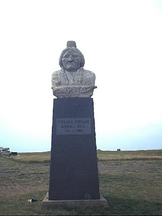 Sitting Bull
Photo: the monument on top of Chief Sitting Bull's grave on a hillside overlooking the Missouri River, across the river from Mobridge, South Dakota and on the reservation of the Standing Rock Nation. The wording on a monument at the base of the mound: 1834-1890. Indian name: Tatanka Iyotake. Sitting Bull was born on the Grand River a few miles west of here. His tragic end came at the very place he was born. He was shot when being arrested because of his alleged involvement with the Ghost Dance craze. Sitting Bull was originally buried at Fort Yates, North Dakota. On April 8, 1953, surviving relatives with the aid of the Dakota Memorial Association moved his remains to the present location and dedicated the memorial burial site April 11, 1953. In 1876 he was victorious at the Battle of Little Big Horn. In 1877 he sought asylum in Canada. In 1881 he returned to the United States, and in 1885 he toured with Buffalo Bill's Wild West Show |
| August 6, 2000 Fargo, North Dakota
|
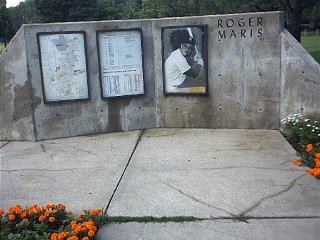
Roger Maris' When Roger Maris died in December, 1985, he was buried here in his hometown of Fargo, North Dakota. There is a museum of his memorabilia here in Fargo, and there are many ballfields all over town. At the park where my campground was I counted eight baseball diamonds. Find out what accomplishment of Roger Maris' first put him in sports history books. Hint: it involves a record set by Babe Ruth. |
| August 6, 2000 Lake Itasca, Minnesota
|
Headwaters of the Mississippi
Please see the August 6, 2000 entry in Flat Teddy's Journal. |
| August 10, 2000 Lake of the Woods, Minnesota
|
 Lake of the Woods
Lake of the Woods, between Minnesota and two provinces of Canada, is one of the world's largest lakes. It is ocean-like in its size and moods. It has 65,000 miles of shoreline and 14,000 islands! Where this picture was taken at Zippel Bay at the south end of the lake it's 80 miles across to the northern tip of the lake! It is 55 miles across at its widest. You are seeing the lake on a calm day, when the waves were lapping mildly at the sandy shoreline. On stormy, windy days the waves crash in like the ocean surf, and they can be very high and dangerous. Up on the west side of the lake, sticking out on a large peninsula, is an area of the United States called the Northwest Angle. The only land it is connected to is in Manitoba, Canada, and the only way to get to it without going through Canada is by boat. The "angle" is the result of the Treaty of Paris in 1783, when the United States Revolutionary War was over and the United States was setting the Canadian boundary with England. The language of the treaty stated that the northwest corner of the Lake of the Woods would belong to the United States. But how do you determine the northwest corner of a lake so irregular in shape? The wording resulted in fifty years of controversy that ended in 1842 when a treaty between the United States and Britain officially established the present boundary between the two countries. |
| August 9, 2000 Voyageurs National Park, near International Falls, Minnesota |
The Voyageurs
Please see the August 9, 2000 entry in Flat Teddy's Journal. |
| August 9, 2000 Voyageurs National Park, near International Falls, Minnesota
|
 Rainy Lake, Voyageurs National Park
Voyageurs National Park
Find Rainy Lake on a map and compare its size to that of Lake of the Woods. The Voyageurs used both lakes to transport beaver pelts. Which lake would have taken them the longest to cross? The route of the Voyageurs through Rainy Lake became so established that
the 1783 treaty ending the American
Revolution
|
| August 10, 2000 Voyageurs National Park, Minnesota
|
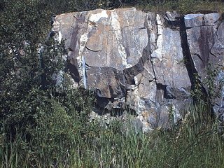 Rocks in northern Minnesota
Picture: 2.7 billion year old rock Voyageurs National Park lies in the southern portion of the Canadian Shield. The ancient sediments that comprise the shield represent some of the oldest rock formations exposed anywhere in the world. Younger rock formations do not appear here. Perhaps they never existed, but more likely glaciation simply removed them. At least four times in the past one million years, continental glaciers--ice sheets two miles thick--bulldozed their way through the area. They removed previous features, leaving mostly level, pock-marked rock up to 2.7 billion years old. Hundreds of ponds, lakes, and streams now nestle in the depressions, and some rock surfaces in the park still bear the scrape marks. Why could we say that the Voyageurs Highway through all these lakes was actually a gift of the glaciers? |
| August 10, 2000 Bayfield, Wisconsin
|
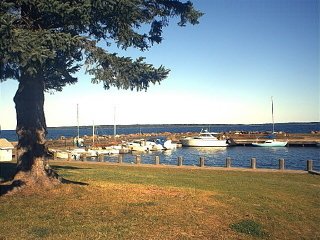
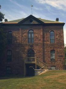
Apostle Islands, Lake Superior (off Bayfield Peninsula, Wisconsin) The Apostle Islands, near the southern end of Lake Superior, were named by missionaries who followed the French fur traders into this area. It was thought that there were twelve islands in this archipelago (and therefore the missionaries named the group after the twelve apostles), but there are in fact twenty-two islands. Twenty-one of them are now within the boundaries of Apostle Islands National Lakeshore, a part of the National Park Service. In the first picture you are looking out across Sand Bay from a point on the mainland over to Sand Island in the distance. The islands are formed of brown sandstone laid down by braided streams about one billion years ago. Sandstone on several of the islands was quarried for about thirty years, beginning in 1869, to furnish brownstone for urban Midwest buildings. In the second picture you see the old county courthouse in Bayfield, Wisconsin, which now serves as park headquarters for the Apostle Islands National Lakeshore and which is built of the brown sandstone quarried from the area. Lake Superior is 360 miles long, 160 miles wide, and 1,332 feet deep at its lowest point. It is the world's most expansive freshwater body. Lake surface altitude lies at about 602 feet elevation, and its bottom, gouged out by Ice Age glaciers, reaches 730 feet below sea level! |
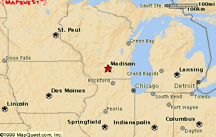
| August 20, 2000 Madison, Wisconsin
|
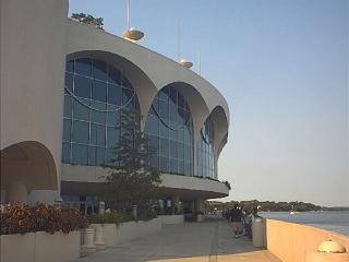 Monona Terrace
Community and Convention Center
Monona Terrace
Community and Convention Center
The capital city of Wisconsin is
Madison, home to two of
Frank Lloyd Wright's |
| August 20, 2000 Oconto, Wisconsin
|
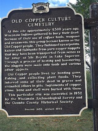 Copper Culture Burial Mound
Oconto, Wisconsin, is the site of a 4000-year-old burial mound of an ancient Copper Culture people. Archeological excavations revealed many artifacts fashioned of copper, which were buried with the dead. Today a park is situated on the site, and there is a path leading up to the small mound, on which is a rock engraved with the name Copper Culture and stating the age of the mound to be about four thousand years. |
| August 20, 2000 Peshtigo, Wisconsin
|
Peshtigo
Fire
Peshtigo, Wisconsin, is the site of a deadly forest fire that killed over 800 people on the night of October 8, 1871--strangely enough, the same night as a much more widely publicized fire that destroyed part of Chicago. The fire was fueled by tinder-dry woods and grasslands, at the end of a dry spring and summer. It was spread by a tornado-force wind that hit that night, driving the fire from the forest right through the town. A thief who had been stealing from damaged houses the next day was sentenced to be hanged. In the whole town, there wasn't an unburned rope to be found for hanging him, and his cries for mercy convinced the crowd to pardon him. He was actually saved by the fire! |
| August 20, 2000 Munising, Michigan
|
The cliffs of Pictured Rocks rise from Lake Superior along forty miles
of shoreline between the towns of Munising
and Grand
Marais, Michigan,
on the Upper
Peninsula. The cliffs are a spectacular example of the
erosive action of waves, wind, and ice. There are many colors of rock
on the cliff faces and fascinating formations carved by nature.
Longfellow |
| August 20, 2000 Sault Ste. Marie, Michigan
|
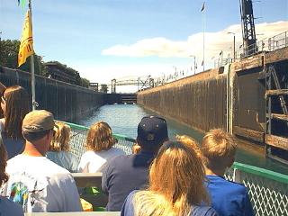
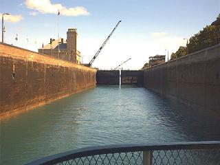 Locks at Sault Ste. Marie
I got a ticket on a one o'clock boat tour through the boat locks at Sault Ste. Marie. I have never been on a boat that was progressing through locks, and it was very exciting. I tried to imagine the scale of the Panama Canal locks as compared to these. There was only one lock from the Ste. Marie River to Lake Superior, and it raised us 20 feet. But still, it was interesting to see the bottom door close behind us and then watch the side of the canal as we rose up through the lock while it filled with water. There was a great "Ah!" from the passengers as the upper lock door opened, and ahead of us we saw the blue waters of Lake Superior shining in the sun. We cruised north across the eastern end of the lake to the Canadian side and past a steel plant. Then we went down through the Canadian locks. I got a good look up at the Ste. Marie rapids as we went past them when we were back down on the Ste. Marie River. They drop twenty feet overall, and they gave the early travelers (the Indians and the voyageurs) such a headache portaging around them! After I was back in the RV I could see a huge Great Lakes ore boat (here is a picture of a historical ore boat) approaching the locks, so I drove over to where I could watch it pass through. It looked as if it would take a person at least five minutes to walk from the bow to the stern of it. A mighty ship. I thought of the Edmund Fitzgerald, which went down in Lake Superior in a huge storm in 1975, taking all hands with it, and wondered how its size compared to this one. |
| August 25, 2000 Mackinac Island, Michigan
|
Mackinac Island
Please see the August 25, 2000 entry in Flat Teddy's Journal. |
| August 25, 2000 St. Ignace, Michigan
|
Mackinac Bridge - Across the Straits of Mackinac
This five-mile-long bridge is one of the longest suspension bridges in the world. It connects the Upper Peninsula of Michigan to the lower section of the state, crossing between the towns of St. Ignace and Mackinaw City. It opened in 1957 and replaced the old ferry crossing between the two sections of Michigan. In the days before the bridge, the line of cars waiting for a ferry would sometimes stretch back as far as twenty miles. Every Labor Day many people participate in the Mackinac Bridge Walk, as the west two lanes are closed to vehicle traffic and people can walk there. The east two lanes remain open for vehicles to drive across. On the right (or west) of the bridge lies Lake Michigan, and on the left (or east) side of the bridge is Lake Huron. The bridge crosses a narrow five-mile-wide passageway called the Straits of Mackinac, between the two Great Lakes. |
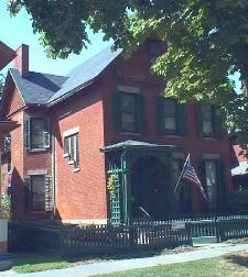
| August 30, 2000 Fort Wayne, Indiana
|
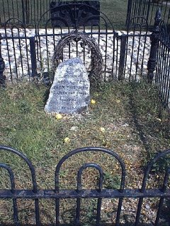 Johnny Appleseed's Gravesite
In Fort Wayne, Indiana, atop a low hill beside the
St. Joseph River sits
this small gravesite. John Chapman, better known as Johnny Appleseed |
| August 25, 2000 Wapakoneta, Ohio
|
Neil Armstrong Space Museum
Please see the August 25, 2000 entry in Flat Teddy's Journal. |
| August 30, 2000 Dearborn, Michigan
|
 "On the Road" Motor-home
This is the last of the motor-homes that Charles Kuralt and his team used for their travels around America as they collected stories for their television show "On the Road." It is on display at the Henry Ford Museum in Dearborn, Michigan. I wondered if someday we'd see Charlie Brown parked right beside Charles Kuralt's RV in this museum! (You see, Charlie Brown isn't named just for Charles Schulz's cartoon character, he's also named in honor of Charles Kuralt.) |
| August 30, 2000 Dearborn, Michigan
|
 Noah Webster
 This house is in Greenfield Village, Dearborn, Michigan. Noah Webster
had this house built in New Haven, Connecticut when he was in his sixties. He was
a great believer in public education and promoted the idea of girls going to school.
He wrote Webster's Blue-Backed Speller in 1782. In 1831 he
published The Elementary Primer, or First Lessons for Children. It cost
6 1/4 cents then. It was created to be an introduction to the Blue-Backed Speller for
younger children. In all, about a hundred million copies of the Blue-Backed Speller have been sold and used around the world. As late as the 1920s many people had fond
memories of learning their spelling lessons from one of these little textbooks.
Henry Ford |
| August 30, 2000 Dearborn, Michigan
|
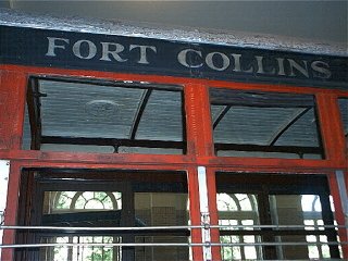 Fort Collins
 Imagine my surprise to look up at this trolley in the Henry Ford Museum in Dearborn, Michigan, and see these words painted on it! The sign beside the trolley says: This trolley is a Burney Safety Car, made in about 1921. This car was used first in Grand Rapids, Michigan. During World War II it saw service in Marion, Indiana, and in 1948 was sold to the Fort Collins, Colorado, Municipal Railway, where it received a complete mechanical overhaul.For me, it was a little piece of home in a place far away. |
| August 27, 2000 Dayton, Ohio
|
The Wright Brothers Bicycle Shop in Dayton, OH
Please see the August 27, 2000 entry in Flat Teddy's Journal. |
| August 27, 2000 Dayton, Ohio
|
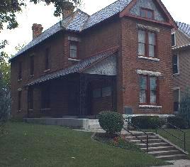 Paul Lawrence Dunbar
State Memorial
Paul Lawrence Dunbar
State Memorial
This house in Dayton,
Ohio, was the home of
Paul Lawrence Dunbar, an
African-American poet, novelist, and civil rights advocate. His
short life spanned the late 19th and early 20th centuries. When he was
in high school in Dayton he edited a newspaper, The Dayton Tattler,
that was printed by the Wright brothers, who had a small business of
printing neighborhood newspapers. Dunbar was a high-school classmate of
Orville Wright. Paul Lawrence Dunbar published twenty-one books during his
lifetime. He had many friends around the world; four prominent friends
were
Frederick Douglass
|
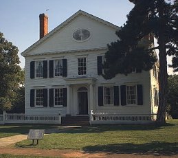
| August 27, 2000 Marion, Ohio
|
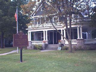 President Warren G. Harding's House
Warren G. Harding had this house built in
Marion, Ohio, his hometown, in 1891. He and his wife
Florence were married in the home on July 8, 1891, and lived in it until
1920, when Harding became President and they moved to
Washington, D.C.
The stress of the presidency, his probable knowledge of at least one of the scandals soon to become public knowledge, and his poor health led to his death while he was in office. He had traveled to Alaska and was in San Francisco, on his way back to Washington, D.C., when he died on August 2, 1923, of either a heart attack or a cerebral hemorrhage. Symptoms recorded at the time point to the possibility of either cause of death. Calvin Coolidge, the Vice President, was sworn in as President. |
| August 28, 2000 Marion, Ohio
|
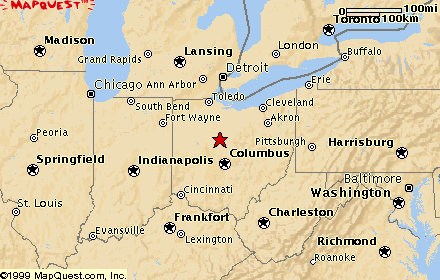
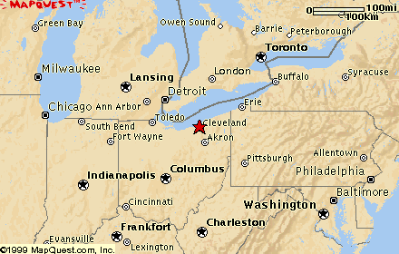
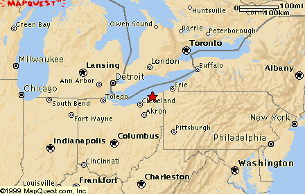
Pictured here is the Rock and Roll Hall of Fame in Cleveland, Ohio. Inside, there are many items on display used by famous rock and roll artists through the years--guitars that Elvis played on, clothes that Madonna wore for filming certain videos, a sheet of paper on which one of the Beach Boys had scribbled lyrics as he was inspired by an idea, record album jackets, candid photographs, and thousands and thousands of things to see. There are also several movie theaters in which one can see such titles as: "The Roots of Rock and Roll," "Rave On: Rock and Roll's Early Years," "Mystery Train," "Kick Out the Jams," "Video Killed the Radio Star," and "Rock Is." There are also kiosks scattered all through the building on all floors where one can put on a set of headphones, touch a computer screen to choose a decade from the 1900's, and listen to music by any artist from each decade, simply by choosing titles displayed on the screen and touching them. The sound fidelity is incredible, and needless to say, I spent a lot of time listening to my old favorites from the 50's and 60's! I was limited by time, so I missed two whole rooms devoted to Hip-Hop and Soul. It was a very fun place to spend an afternoon in Cleveland! |
| August 29, 2000 Madison, Ohio
|
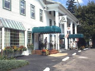 The Old Tavern
This is The Old Tavern in
Madison, Ohio, near the shore of
Lake Erie
|
| August 29, 2000 Madison, Ohio
|
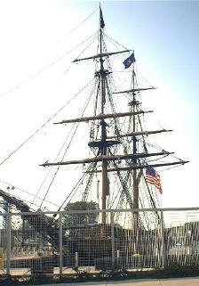 Perry and the "Niagara"
The sailing ship in this picture is a little hard to see because I was
taking the photograph in the last light of day through a chain-link
fence. The exhibit had closed by the time I got there, so I didn't get to
go inside the fence. I wanted you to see the ship, anyway. It's the
"Niagara," an exact
replica of the sailing ship that was commanded by Commodore
Oliver Hazard Perry in the
decisive battle against the British in Lake Erie in
the War of 1812
|
| August 30, 2000 Niagara, New York
|
Niagara Falls
Please see the August 30, 2000 entry in Flat Teddy's Journal. |
| August 31, 2000 Rochester, New York
|
 Susan B. Anthony House
Susan B. Anthony
After the Civil War, when congress approved an amendment to the constitution giving African Americans the right to vote, the first statement in the amendment said that the right to vote would not be denied anyone, regardless of race, creed, or color. Further down in the text of the amendment it was clearly stated that the people referred to in the amendment were men. But Susan B. Anthony decided to put the first sentence of the amendment to a test. She got a few women together in 1872, the first election after the voting rights amendment went into effect, and they marched down to the polls and demanded ballots. The men at the polling booth were aghast at these women's impropriety, but they did not want to create a disturbance that would invite publicity. They decided to let them vote, and the women did so. Later, police arrived at Susan B. Anthony's house, and it was in her living room, pictured here, that she was arrested for breaking the law and voting. She spent only a few hours in jail, but the public outrage from that incident greatly furthered the cause of women's suffrage. |
| August 31, 2000 Rochester, New York
|
 Frederick Douglass Museum
Frederick Douglass
Douglass became an ardent abolitionist, choosing Rochester, New York, to be his home for over twenty-five of his adult years. He was an eloquent orator, writer, and public servant. He became known the world over as an abolitionist and human rights advocate. He was a friend of Susan B. Anthony, and he gave his support to help her and others in the women's suffrage movement after black American men were given the right to vote. Both he and Susan B. Anthony are buried in Mount Hope Cemetery in Rochester. The building in the picture is the Frederick Douglass Museum and Cultural Center, the mission of which is to celebrate Douglass' achievements, commemorate his presence in Rochester, and explore his legacy of civic action in contemporary culture. |
| August 31, 2000 Palmyra, New York
|
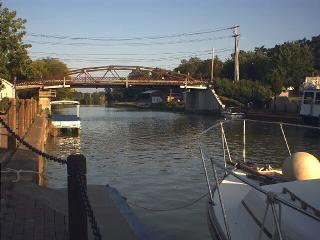
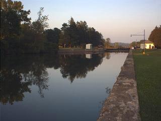 Erie Canal
These two pictures are of the Erie Canal, which is still in use today. It was designed and built in the early 1800's to transport goods between the Hudson River in eastern New York State and Buffalo on the shore of Lake Erie. The first picture shows the Erie Canal as it passes through the town of Palmyra, New York. You can see a bridge that carries traffic of one of the city streets crossing the canal. The second picture shows a lock outside of Palmyra. The lock is full of water, and the lower lock gate is shut. The Erie Canal was built to ship raw materials from the Great Lakes region to manufacturing areas of the eastern states, which had access to the Hudson River or to railroad lines. And the canal carried barges laden with goods to transport to settlements in western New York and on up the Great Lakes. Today the canal is used by individual pleasure craft and tour boats. When I arrived at this spot it was very late in the afternoon, and the only cruise I could book was a dinner cruise with a theme of murder mystery. It sounded like fun, but I wouldn't have gotten back to Charlie Brown until way past time to be finding a campground for the night. I sadly didn't get the experience of traveling a ways on the Erie Canal. I understand that it is possible to travel the length of the canal in a boat. Someday... |
| September 1, 2000 Seneca Falls, New York
|
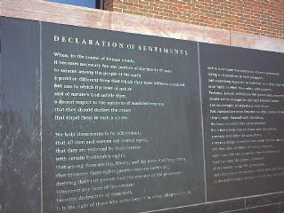 Women's Rights National Historical Park
Seneca Falls, New York, at the north end of Cayuga Lake, in 1848 became the site of the opening skirmish in the battle for women's rights. A group of women, mostly Quakers, had gathered for tea one morning and invited Elizabeth Cady Stanton. The Quakers were ardent abolitionists and involved in the effort to win the battle against slavery in this country. The next step seemed to be getting equal rights for women. In those days, a married woman could not vote, make contracts, divorce an abusive husband, gain custody of her children, or own property--even her own clothing! If she inherited property or wealth from her family, it became the property of her husband. These women on that particular morning decided that the time had come to make public the need for equal rights for women. They planned a convention and held it in Wesleyan Chapel (of which a few walls remain and are protected from the elements so that we can see it today). They drew up and read a list of grievances based on the Declaration of Independence, called the Declaration of Sentiments, denouncing inequities in property rights, education, employment, religion, marriage and family, and suffrage (right to vote.) The Declaration of Sentiments began: We hold these truths to be self-evident: that all men and women are created equal.This picture shows the granite water wall, just outside the chapel, that is engraved with the total text of the Declaration. |
| September 1, 2000 Seneca Falls, New York
|
Elizabeth Cady Stanton moved to this home in Seneca Falls, New York, with her husband Henry (a lawyer and an ardent abolitionist lecturer) and three young sons. It was here in Seneca Falls that Stanton's political stance on women's rights became fixed and very public. In the previous report you read about the tea party at which she first voiced her unhappiness with women's lot in America. She soon became acquainted with Susan B. Anthony in Rochester, not too far away from Seneca Falls. The two became fast friends and would remain close for the rest of their lives. Stanton was tied to home and family responsibilities that prevented her from traveling and speaking outside the local area, but she did much of the speech-writing for the cause. Susan B. Anthony was free of those domestic duties which confined Stanton to home, so she became the traveler and speech-giver. One time Stanton wrote Anthony a letter saying that if Susan would get over to Seneca Falls and help with the children, maybe Elizabeth could get some writing done! Susan spent several weeks at a time there, many times, helping out with the children. The three boys were quite mischievous, to put it mildly, and they weren't altogether happy when "Aunt Susan" came to stay with them because she was much stricter with them than their parents were. |
|
Links Back to the main page... |